Powered By Blogger

Friday, 14 March 2014

Edlingham Castle


Edlingham Castle doesn’t follow the normal trend of being situated on a good defensive foundation as it lies at the bottom of a valley between Alnwick and Rothbury. 

 
The Bleak Northumberland Landscape


By 1174, John de Edlingham built a two storey Hall House in a moated enclosure in the mid thirteenth century.. In 1296 the property was taken over by William de Felton who added a palisade and a gatehouse, fortifying the main hall and adding other buildings inside the courtyard


In 1298 William de Felton built a hall house with a three storey residential tower.  In 1396 Elizabeth de Felton inherited it, marrying Sir Edmund Hastings, who added a strong solar tower. Their descendants occupied the castle and estate until 1514; it was then it was purchased by George Swinburne; a constable of Prudhoe, whose family held it until the 18th century. 


The hall is the earliest standing structure at Edlingham. This dates from the period 1295-1300. It almost certainly had vaulted cellars topped by a great hall, or living area. The hall was rectangular, with an octagonal turret at each corner.  The tower house is now nearly free-standing, though it was originally connected to the hall by a passage.  The highlight still remains the 15th Century solar tower.

Friday, 7 March 2014

Warkworth Castle


 Before the Norman conquest, it is believed there was a stronghold, built by Ceolwulph, a Northumbrian King.  In 1158 Henry II bestowed the manor upon Roger Fitz-Richard, the ancestor of the Clavering family.  Roger set about fortifying the property and built a castle.  In 1173 William the Lion crossed the border to support his claim for possession  of Northumberland as part of the Scottish kingdom and the castle was destroyed.  However it was quickly rebuilt and in the reign of Edward II, the manor of Warkworth, and the castle, reverted to the Crown.  Eventually it became the principle seat of the second Lord Percy of Alnwick.


Castle Gates

In 1403 an attempt was made to raise the north in rebellion against the king and the Earl of Northumberland was a leading player.  The Earl went to meet the king and was promptly put into prison and the castle along with Prudhoe and Alnwick castles reverted back to the king.  The Earl was later set free but again chanced his luck at rebellion.  The king marched into Northumberland and the Earl fled north of the border leaving his castles behind.

John of Lancaster, son of the king, was made Warden of the East March and took up residence at Warkworth.  In 1462 Edward IV granted the residence to his brother, George, Duke of Clarence and in 1463 was besieged by Sir Ralph Grey.  Under Henry VII, the manor came back to the Percies and has remained since.
Castle Keep


The Lion Tower
 
In 1569 The Earl of Northumberland joined in a rebellion caused by changes of the Reformation.  The rebellion proved a failure and the Earl took off for north of the border.  Sir John Forster took possession of the castle.

The Lion Tower


The last Percy earl died in 1670. In the mid-18th century the castle found its way into the hands of Hugh Smithson, who married the indirect Percy heiress. He adopted the name "Percy" and founded the dynasty of the Dukes of Northumberland, through whom possession of the castle descended.

In the late 19th century, the dukes refurbished Warkworth Castle and Anthony Salvin was commissioned to restore the keep. Alan Percy, 8th Duke of Northumberland gave custody of the castle to the Office of Works in 1922. Since 1984 English Heritage  has cared for the site, which is a Grade I listed building.


The Great Hall

Entrance to the Lion Tower


The Chapel inside the Keep


Warkworth castle is also famous for starring in one or two passages from Shakespear’s “King Henry IV”

Wednesday, 5 February 2014

Aviemore, Scotland.


Aviemore is a town and tourist resort, situated within the Cairngorms National Park in the Highlands of Scotland. The town is popular for skiing and other winter sports, and for hill-walking in the Cairngorm Mountains.


CAIRNGORMS


Aviemore has been in existence since the 1600s, the quiet growth of this historic village of Aviemore began in the 1800s with the advent of the railways, when it functioned as a small junction on the old Highland Railway. It is situated on the plain overlooked by the Monadhliath and Cairngorm Mountains. With the advent of the rail, travel inevitably became easier in this previously inaccessible area of Scotland. Aviemores’ popularity as a holiday destination grew, especially with Queen Victoria who visited regularly, enjoying the nearby spa village of Grantown-on-Spey
Loch an Eilen


Castle on Loch an Eilen

 
Loch Morlich
Carn Lochan na Bienne


The awesome Cairngorms beckoned to the intrepid explorers, climbers and geologists of the time, many of whom were already hardy visitors to Aviemore, seeking a challenge and the truth of existence. In the 1800s many of these geologists combed the Cairngorm Mountain range searching for the cairngorm semi-precious stone, a wonderful pale gold or amber in colour,

 
Storm Clouds over Loch Morlich

The village began to grow as a result of it becoming a railway junction in 1898, following which the Highland Railway became a major constructing housing for its staff and the Aviemore Hotel. Aviemore became one of the first skiing resorts to be established in Scotland with the opening of the chairlift in 1961 and is also notable for being near the freely grazing reindeer herd at Glen More, the only one in the United Kingdom.  The resort has since grown into Britain's most visited ski resort during the winter months.


Sunday, 26 January 2014

Amble


Amble was originally located well to the south of the mouth of the River Coquet, however in March 1764, the river below Warkworth changed its course due to heavy rain. The river sought its most direct route to the sea and broke its banks across a broad meander and as a consequence Amble found itself less than one third of a mile from the new river mouth.
In 1204 the spelling used was Ambell’ and by 1610 it was Anbell’. However by 1769 The modern name of Amble was being used. The name Amble is generally accepted to mean ‘Anna’s Bill’ or ‘Anna’s Promontory’.  For a short time in the 1980’s Amble was officially known as Amble-by-the-Sea, however this was dropped in 1985 and the town reverted back to being called Amble.


Amble owes much of its growth and early prosperity to the 19th century coalfields from which it used to ship coal to southern England and the Continent. As collieries were opened; Amble’s location at the mouth of the River Coquet, and its railway links to the Northumberland coalfields, made it a centre for the transportation and export of coal.  Prior to this development the town was little more than a hamlet. The principle local mineworkings were those at Broomhill  and at Radcliffe. Today, the collieries in Northumberland are all closed (the last, Ellington, closed in 2005), and the railway no longer serves Amble.
Other industries, such as ship building and repair, and sea fishing, expanded with the growth of the town, although traditional Northumbrian fishing vessels such as cobles have sheltered in the natural harbour here for many centuries previously.
To the north of the town, along the riverside land known as The Braid was originally the site of a shipyard. Boat building began in Amble at the end of the 18th century when the ‘Chevington Oak’ was built with wood from nearby Chevington Woods. There was also a joinery yard and sawmill on the Braid on the site where the Marina Arms now stands.


The harbour had a brickworks, boatyards, and an extensive network of high-level railway lines serving timber coal staithes around the harbour at the Radcliffe and Broomhill Quays. The town’s railway station was built in 1878 and was approached by a sloping ramp from Church Street.In the 1930s, when the RMS Mauretania was heading on her last voyage to the breaker's yard at Rosyth, the town council of Amble sent a telegram to the ship saying "still the finest ship on the seas". The Mauretania replied with greetings "to the last and kindliest port in England"


Today, Amble is Northumberland's most important fishing centre north of the River Tyne. The fishing industry survives, although it has reduced numbers of vessels now, as does a small marine industry - mainly concentrated around the construction and repair of yachts and other pleasure craft. Leisure sailing has also become important and, as well as the marina, the town has a vibrant yacht and boat club. A small industrial estate is located to the southwest of the town, whose clients include food processing plants, vehicle repairs and telecommunications companies. Amble also has a number of good shops including Tesco and Boots, gift shops, and many pubs and fast food outlets. Tourism now forms an important sector of Amble’s economy. Part of the harbour was redeveloped into a marina with secure berths for 250 vessels which opened in 1987. The outer boundary of the marina incorporates one of the original timber jetties from the early harbour as part of the old river bed was reclaimed during construction.  


Sunday, 19 January 2014

Eyemouth, Scotland


Eyemouth is a small town  Berwickshire in the Scottish Borders with a population of about 3,420 people (2004).

The town's name comes from its location at the mouth of the Eye Water. The Berwickshire coastline consists of high cliffs over deep clear water with sandy coves and picturesque harbours. In the main it is a fishing port, although notable buildings in the town include Gunsgreen House and a cemetery watch house built to stand guard against the Resurrectionists (body snatchers). Many of the features of a traditional fishing village are preserved in the narrow streets and vennels – giving shelter from the sea and well suited to the smuggling tradition of old.


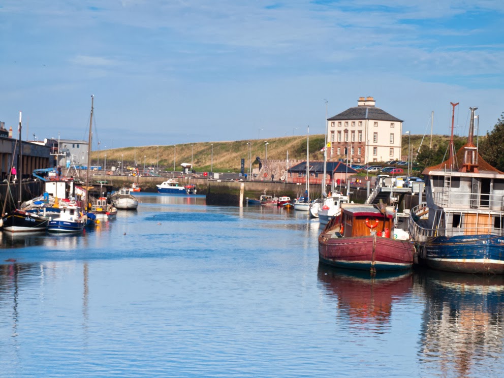
Eyemouth Harbour

The life of the historical hero of the town, William Spears (1812–1885), is celebrated by the dramatic bronze statue in Eyemouth Market Place, where he stands pointing the way to Ayton, the scene of his peaceful demonstration. At great personal risk, Spears led a revolt against the tithes on fish levied by the Church of Scotland, even after the great Disruption of 1843 when most fishermen left the established Church to join other congregations.
Very soon after the cost of getting the tithes removed had been met, the town was struck by the Eyemouth Disaster when on 14 October 1881 most of the fishing fleet, some 20 boats and 129 men from the town were lost in a terrible storm. Including victims from other coastal towns, a total of 189 men lost their lives. This is commemorated in the Tapestry housed in the Museum.


A contemporary article offers an interesting insight into Eyemouth in the 1860s:
"Between Abbs Head and Berwick, however is situated Eyemouth, a fishing-village pure and simple, with all that wonderful filth scattered about which is a sanitary peculiarity of such towns.
The population of Eyemouth is in keeping with the outward appearance of the place. As a whole, they are rough, uncultivated, and more druken in their habits than the fishermen of the neighbouring villages. Coldingham Shore, for instance, is only three miles distant, and has a population of about one hundred fishermen, of a very respectable class, sober and well dressed, and "well to do." – The Fisher Folk of the Scottish East Coast, "Macmillian's Magazine" No.36 October 1862.
The wide sandy bay is flanked by high cliffs. Despite being sheltered by the Hurkur Rocks, storms can generate high waves and throw high plumes of spume into the air over the sea wall. Named "The Bantry" said to be in affectionate memory of the Irish labourers, from the fishing town of that name in County of Cork, who constructed it.


In 1997, Eyemouth was given EU funding from a scheme to regenerate declining fishing villages and raised matching funds itself to construct a deep water extension to the Harbour. Eyemouth Harbour caters for most types of fishery activity and as a result Eyemouth's primary industry has seen a certain amount of rejuvenation. A pontoon has been installed in the harbour to provide ease of boarding for seafarers. This has attracted an increasing number of pleasure craft. Walks round the harbour never fail to interest. This is a real working fishing port and the scene is constantly changing.


Feeding the Seals


Wednesday, 17 April 2013

Hartside to Hedgehope Hill

This walk covered approximately 8miles however quite a bit was following the snowy paths leading up to Hedgehope hill. If you have ever had the misfortune to hike the hills through knee and thigh deep snow you would realise Hell doesn't hold the patent on all forms of torture.  I must admit that at one point in  this wonderful hike I was lying prostrate with my face buried in the compact snow of Hedgehope hill wondering how long it would take the emergency services to airlift me from exhaustion.  Being a photographer I have always combined my walks in the hills with the opportunity to capture some great landscape shots, however this does mean you have to carry all of your camera equipments, lenses, tripod etc along with heavy weather kit, kettle, litres of water and sandwiches.  The weight of my very large rucksac would pose problems for the military but you never know when you might get that special shot - such is the mentality of an idiot/photographer (delete as appropriate).  Combine a very heavy rucksac with thigh deep snow and you start to get the picture of the pain I went through for the sake of enjoyment....!!  The following images take you from Hartside in Ingram Valley, through Linhope and to the waterfalls of Linhope Spout, upwards between Great Staindrop and Dunmoor Hill to the majesty of Hedgehope and back.

Before I lead you through the delights of the Cheviots I would like to share a quote from the author George MacDonald Fraser when he wrote his very informative book on the region and the Border Reviers - "The Steel Bonnets"

The whole region, the very heart of Britain, contains some of the lonliest and some of the bleakest country in the British Isles.  Along the central part of the frontier line itself is the great tangled ridge of the Cheviots, a rough barrier of desolate treeless tops and moorland with little valleys and gulley’s running every way, like a great rumpled quilt……One walks in them with head constantly turning to the long crests on either side, but seeing nobody.  Like their relations, the Cumberland fells and the broken foothills of the Southern Uplands, they are melancholy mountains; probably only the border people feel at home in them, but even the incomer will recognise them as the most romantic hills in  the world 

George MacDonald Fraser, “The Steel Bonnets”.


The road from Hartside to Linhope


From Linhope to Linhope Spout


In 1870-72, John Marius Wilson's Imperial Gazetteer of England and Wales described Linhope like this:

LINHOPE, a hamlet in Ingram, Linhope, and Greenshawhill township, Ingram parish, Northumberland; on the river Breamish, under the Cheviots, 8½ miles SW by S of Wooler. The name Linhope signifies "the valley of the waterfall, ''and alludes to a cascade called Linhope Spout. The cascade is a fall of 56 feet, over a precipitous rock, into a dark ravine, flanked with high birchclad rocks. Remains of an ancient fortified British town are at a spot called Greaves-Esh; and comprise three circular encampments, each with surrounding ramparts, enclosing perceptible foundations of houses. The W encampment is the largest, and has 18 hut-circles. A small silver cross, inscribed with the name of Acca, Bishop of Hexham, and thought to have been one of the crosses given to the Hexham pilgrims, was found, in 1861, at the foot of the adjoining Cheviot hill Hartside.
 
Linhope Burn


Linhope Spout
 
 
 Which way now??
 
 
Hedgehope Hill in the distance
 
Hedgehope Hill is at a height of 714 metres (2,343 ft) and a distance of about 3 miles (4.8 km) from the Scottish Border, it canbe climbed from Langleeford in the Harthorpe Valley, over which it looms, or from Linhope.  An alternative route to the summit could involve a long days climb of both the Cheviot and Hedgehope Hill starting and finishing at Langleeford. It is a steep climb from any approach with steeper sides than the taller but flatter topped Cheviot.
 
 
Climbing Hedgehope
 
The mighty Hedgehope Hill
 

Heading back down with Ritto Hill in  the distance
 
Please take the oppoprtunity to look at my website for more great images of Northumberland